.hero.jpg?w=1024)
Description
Siem Reap is the capital city of Siem Reap Province in northwestern Cambodia. Angkor was the capital city of the Khmer Empire, which flourished from approximately the 9th to 15th centuries.
Angkor was a megacity supporting at least 0.1 % of the global population during 1010 - 1220. The city houses the magnificent Angkor Wat.
The word Angkor is derived from the Sanskrit Nagara, meaning “city”. The Angkorian period began in AD 802, when the Khmer Hindu monarch Jayavarman II declared himself a “universal monarch” and “god-king”, and lasted until the late 14th century, first falling under Ayutthayan suzerainty in 1351. …
Show the remaining text
A Khmer rebellion against Siamese authority resulted in the 1431 sacking of Angkor by Ayutthaya, causing its population to migrate south to Longvek.
The ruins of Angkor are located amid forests and farmland north of the Great Lake (Tonlé Sap) and south of the Kulen Hills, near Siem Reap city.
The temples of the Angkor area number over one thousand, ranging in scale from nondescript piles of brick rubble scattered through rice fields to the Angkor Wat, said to be the world’s largest single religious monument.
Many of the temples at Angkor have been restored, and together, they comprise the most significant site of Khmer architecture.
In 2007, an international team of researchers using satellite photographs and other modern techniques concluded that Angkor had been the largest pre-industrial city in the world, with an elaborate infrastructure system connecting an urban sprawl of at least 1,000 km² to the well-known temples at its core.
Angkor is considered to be a “hydraulic city” because it had a complicated water management network, which was used for systematically stabilizing, storing, and dispersing water throughout the area.
This network is believed to have been used for irrigation in order to offset the unpredictable monsoon season and to also support the increasing population.
Although the size of its population remains a topic of research and debate, newly identified agricultural systems in the Angkor area may have supported up to one million people.
Angkor Wat is a temple complex in Cambodia and the largest religious monument in the world, with the site measuring 162.6 hectares.
It was originally constructed as a Hindu temple of god Vishnu for the Khmer Empire, gradually transforming into a Buddhist temple towards the end of the 12th century.
It was built by the Khmer King Suryavarman II in the early 12th century in Yaśodharapura the capital of the Khmer Empire, as his state temple and eventual mausoleum.
Breaking from the Shaiva tradition of previous kings, Angkor Wat was instead dedicated to Vishnu. As the best-preserved temple at the site, it is the only one to have remained a significant religious centre since its foundation.
The temple is at the top of the high classical style of Khmer architecture. It has become a symbol of Cambodia, appearing on its national flag.
Angkor Wat combines two basic plans of Khmer temple architecture: the temple-mountain and the later galleried temple. It is designed to represent Mount Meru, home of the devas in Hindu mythology: within a moat and an outer wall 3.6 km long are three rectangular galleries, each raised above the next. At the centre of the temple stands a quincunx of towers. Unlike most Angkorian temples, Angkor Wat is oriented to the west.
The Bayon is a well-known and richly decorated Khmer temple at Angkor in Cambodia. Built in the late 12th or early 13th century as the official state temple of the Mahayana Buddhist King Jayavarman VII, the Bayon stands at the centre of Jayavarman’s capital, Angkor Thom.
Following Jayavarman’s death, it was modified and augmented by later Hindu and Theravada Buddhist kings in accordance with their own religious preferences.
The Bayon’s most distinctive feature is the multitude of serene and smiling stone faces on the many towers which jut out from the upper terrace and cluster around its central peak.
The temple is known also for two impressive sets of bas-reliefs, which present an unusual combination of mythological, historical, and mundane scenes.
Map
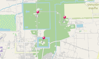
★ Open the Google Maps link in a new window at the location: Bayon, Ta Prohm, Angkor Wat
Photo gallery
109 Photos
Photos 1 to 60
.jpg)
.jpg)
.jpg)
.jpg)
.jpg)
.jpg)
.jpg)
.jpg)
.jpg)
.jpg)
.jpg)
.jpg)
.jpg)
.jpg)
.jpg)
.jpg)
.jpg)
.jpg)
.jpg)
.jpg)
.jpg)
.jpg)
.jpg)
.jpg)
.jpg)
.jpg)
.jpg)
.jpg)
.jpg)
.jpg)
.jpg)
.jpg)
.jpg)
.jpg)
.jpg)
.jpg)
.jpg)
.jpg)
.jpg)
.jpg)
.jpg)
.jpg)
.jpg)
.jpg)
.jpg)
.jpg)
.jpg)
.jpg)
.jpg)
.jpg)
.jpg)
.jpg)
.jpg)
.jpg)
.jpg)
.jpg)
.jpg)
.jpg)
.jpg)
.jpg)
★ Don’t miss: The most beautiful photos of Asia (Middle format)
Related topics
.hero.jpg?w=320)
Archeological sites
2,135 Photos
Archeological sites around the world.
-Cave-19-(Chaitya-Griha).hero.jpg?w=320)
Buddhist - hindu temples
2,571 Photos
Buddhist - Hindu temples around the world.
.hero.jpg?w=320)
Cambodia
265 Photos
Cambodia (ព្រះរាជាណាចក្រកម្ពុជា), the successor state of the once powerful Hindu and Buddhist Khmer Empire, has an area of about 180,000 km², sharing border …
.hero.jpg?w=320)
World Heritage Site (UNESCO)
7,850 Photos
Photo gallery of UNESCO World Heritage Sites. A World Heritage Site is a landmark or area with legal protection by an international convention administered …
.map.png)