.hero.jpg?w=1024)
Description
Chittaurgarh (Chittorgarh), is a city and a municipality in Rajasthan state of western India. It lies on the Berach River, a tributary of the Banas, and is a former capital of the Sisodia clans of Rajputs of Mewar.
Fiercely independent, the fort of Chittaur was under siege thrice and each time they fought bravely and thrice Jauhar was committed by the ladies and children, first lead by Rani Padmini, and later by Rani Karnavati.
The Chittaurgarh Fort is the largest fort in India.
Main sights
- The Chittaurgarh Fort seated on a 180 m hill, covers an expanse of 2.8 km². …
Show the remaining text
- The Kalika Mata Temple was originally built in the 8th century for Sun God and was later converted to a temple for mother Goddess, Kali in the 14th century.
- The Vijay Stambh, a huge nine storey tower which was built by Maharana Kumbha to commemorate his victory over the Muslim rulers of Malwa and Gujarat in 1440. The tower is 37 m high.
- The Kirti Stambh is a tower dedicated to Adinatha, the first of the Jain Tirthankar.
- The Rana Kumbha’s Palace is near the Vijay Stambh. This is the birthplace of Maharana Udai Singh the founder of Udaipur.
- The Rani Padmini’s Palace is from which Alauddin Khalji was allowed to watch a reflection of the Rani by placing the mirror in such an angle that even if Khalji turned back he could not see the room.
Map
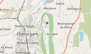
★ Open the Google Maps link in a new window at the location: Chittaurgarh
Photo gallery
69 Photos
.jpg)
.jpg)
.jpg)
.jpg)
.jpg)
.jpg)
.jpg)
.jpg)
.jpg)
.jpg)
.jpg)
.jpg)
.jpg)
.jpg)
.jpg)
.jpg)
.jpg)
.jpg)
.jpg)
.jpg)
.jpg)
.jpg)
.jpg)
.jpg)
.jpg)
.jpg)
.jpg)
.jpg)
.jpg)
.jpg)
.jpg)
.jpg)
.jpg)
.jpg)
.jpg)
.jpg)
.jpg)
.jpg)
.jpg)
.jpg)
.jpg)
.jpg)
.jpg)
.jpg)
.jpg)
.jpg)
.jpg)
.jpg)
.jpg)
.jpg)
.jpg)
.jpg)
.jpg)
.jpg)
.jpg)
.jpg)
.jpg)
.jpg)
.jpg)
.jpg)
★ Don’t miss: The most beautiful photos of India
Related topics
-Cave-19-(Chaitya-Griha).hero.jpg?w=320)
Buddhist - hindu temples
2,571 Photos
Buddhist - Hindu temples around the world.
.hero.jpg?w=320)
India
3,829 Photos
India (भारत गणराज्य), officially the Republic of India, is a country in South Asia. It is the seventh-largest country by area, the second-most populous …
.hero.jpg?w=320)
World Heritage Site (UNESCO)
7,850 Photos
Photo gallery of UNESCO World Heritage Sites. A World Heritage Site is a landmark or area with legal protection by an international convention administered …
.map.png)