-Windmills.hero.jpg?w=1024)
Description
Kinderdijk, in the province South Holland, is located about 15 km east of Rotterdam and situated in a polder at the confluence of the Lek and Noord rivers.
To drain the polder, a system of 19 windmills was built around 1740. This group of mills is the largest concentration of old windmills in the Netherlands.
The windmills of Kinderdijk are one of the best known Dutch tourist sites. They were placed on the list of UNESCO list of World Heritage Sites in 1997.
The name Kinderdijk is Dutch for “Children’s Dike”. In 1421 during the Saint Elizabeth flood of 1421, the Grote Hollandse Waard flooded, but the Alblasserwaard polder stayed unflooded. …
Show the remaining text
It is said that when the terrible storm had subsided, someone went on to the dike between these two areas, to see what could be saved.
He saw in the distance a wooden cradle floating. There was no hope that anything would be living in it, but when it approached, movement was seen.
When the cradle came nearer, someone saw that a cat was in the cradle trying to keep it in balance by jumping back and forth so that no water could come into it.
When the cradle eventually came near the dike, someone fished the cradle out and saw that in it a baby slept quiet and dry. In some of the stories the cat kept it balanced and afloat.
This folktale and legend has been published as “The Cat and the Cradle” in English.
Map
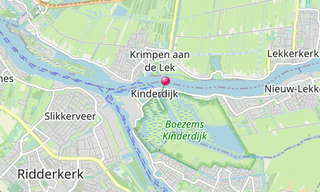
★ Open the Google Maps link in a new window at the location: Kinderdijk
Photo gallery
70 Photos
-Windmills.jpg)
-Windmills.jpg)
-Windmills.jpg)
-Windmills.jpg)
-Windmills.jpg)
-Windmills.jpg)
-Windmills.jpg)
-Windmills.jpg)
-Windmills.jpg)
-Windmills.jpg)
.jpg)
-Windmills.jpg)
-Windmills.jpg)
-Windmills.jpg)
-Windmills.jpg)
-Windmills.jpg)
-Windmills.jpg)
-Windmills.jpg)
-Windmills.jpg)
-Windmills.jpg)
-Windmills.jpg)
-Windmills.jpg)
-Windmills.jpg)
-Windmills.jpg)
-Windmills.jpg)
-Windmills.jpg)
-Windmills.jpg)
-Windmills.jpg)
-Windmills.jpg)
-Windmills.jpg)
-Windmills.jpg)
-Windmills.jpg)
-Windmills.jpg)
-Windmills.jpg)
-Windmills.jpg)
-Windmills.jpg)
-Windmills.jpg)
-Windmills.jpg)
-Windmills.jpg)
-Windmills.jpg)
-Windmills.jpg)
-Windmills.jpg)
-Windmills.jpg)
-Windmills.jpg)
-Windmills.jpg)
-Windmills.jpg)
-Windmills.jpg)
-Windmills.jpg)
-Windmills.jpg)
-Windmills.jpg)
-Windmills.jpg)
-Windmills.jpg)
-Windmills.jpg)
-Windmills.jpg)
-Windmills.jpg)
-Windmills.jpg)
-Windmills.jpg)
-Windmills.jpg)
-Windmills.jpg)
-Windmills.jpg)
★ Don’t miss: The most beautiful photos of the Benelux
Related topics
.hero.jpg?w=320)
Netherlands
1,795 Photos
The Netherlands is a constituent country of the Kingdom of the Netherlands, located mainly in North-West Europe and with some islands in the Caribbean. …
.hero.jpg?w=320)
World Heritage Site (UNESCO)
7,850 Photos
Photo gallery of UNESCO World Heritage Sites. A World Heritage Site is a landmark or area with legal protection by an international convention administered …
.map.png)