-(034).hero.jpg?w=1024)
Description
Sakrisøy (Sakrisøya) is a small island and a fishing village between Reine and Hamnøy in the municipality of Moskenes in Lofoten.
The island is located in the Reinefjord, between Andøya and Olenilsøya. The highest point on the island is 18.5 m above sea level.
European road E10 crosses Sakrisøy on the north side.
Map
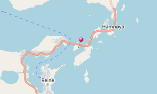
★ Open the Google Maps link in a new window at the location: Sakrisøy
Photo gallery
6 Photos
-(034).jpg)
-(079).jpg)
-(055).jpg)
-(073).jpg)
-(163).jpg)
-(118).jpg)
★ Don’t miss: The most beautiful photos of Norway
Related topics
.hero.jpg?w=320)
Iceland
191 Photos
Iceland is a Nordic island country of Europe located in the North Atlantic Ocean. It has a population of 332,529 and an area of 103,000 km², making it the …
-(121).hero.jpg?w=320)
Norway
131 Photos
Lofoten is an archipelago in the county of Nordland, Norway. Lofoten is known for a distinctive scenery with dramatic mountains and peaks, open sea and …
.hero.jpg?w=320)
Seaside villages
3,438 Photos
The most beautiful seaside villages around the world.