.hero.landscape.jpg?w=1600)
.jpg)
.jpg)
.jpg)
.jpg)
.jpg)
.jpg)
.jpg)
.jpg)
.jpg)
.jpg)
.jpg)
.jpg)
.jpg)
.jpg)
.jpg)
.jpg)
.jpg)
.jpg)
.jpg)
.jpg)
.jpg)
.jpg)
.jpg)
.jpg)
.jpg)
.jpg)
.jpg)
.jpg)
.jpg)
.jpg)
.jpg)
.jpg)
.jpg)
.jpg)
.jpg)
.jpg)
.jpg)
.jpg)
.jpg)
.jpg)
.jpg)
.jpg)
.jpg)
.jpg)
.jpg)
.jpg)
.jpg)
.jpg)
.jpg)
.jpg)
.jpg)
.jpg)
.jpg)
.jpg)
.jpg)
.jpg)
.jpg)
.jpg)
.jpg)
.jpg)
.jpg)
.jpg)
.jpg)
.jpg)
.jpg)
.jpg)
.jpg)
.jpg)
.jpg)
.jpg)
.jpg)
.jpg)
.jpg)
.jpg)
.jpg)
.jpg)
.jpg)
.jpg)
.jpg)
.jpg)
.jpg)
.jpg)
.jpg)
.jpg)
.jpg)
.jpg)
.jpg)
.jpg)
.jpg)
.jpg)
.jpg)
.jpg)
.jpg)
.jpg)
.jpg)
.jpg)
.jpg)
.jpg)
.jpg)
.jpg)
.jpg)
.jpg)
.jpg)
.jpg)
.jpg)
.jpg)
.jpg)
.jpg)
.jpg)
.jpg)
.jpg)
.jpg)
.jpg)
.jpg)
.jpg)
.jpg)
.jpg)
.jpg)
.jpg)
.jpg)
.jpg)
.jpg)
.jpg)
.jpg)
.jpg)
.jpg)
.jpg)
.jpg)
.jpg)
.jpg)
.jpg)
.jpg)
.jpg)
.jpg)
.jpg)
.jpg)
.jpg)
.jpg)
.jpg)
.jpg)
.jpg)
.jpg)
.jpg)
.jpg)
.jpg)
.jpg)
.jpg)
.jpg)
.jpg)
.jpg)
.jpg)
.jpg)
.jpg)
.jpg)
.jpg)
.jpg)
.jpg)
.jpg)
.jpg)
.jpg)
.jpg)
.jpg)
.jpg)
.jpg)
.jpg)
.jpg)
.jpg)
.jpg)
.jpg)
.jpg)
.jpg)
.jpg)
.jpg)
.jpg)
.jpg)
.jpg)
.jpg)
.jpg)
.jpg)
.jpg)
.jpg)
.jpg)
.jpg)
.jpg)
.jpg)
.jpg)
.jpg)
.jpg)
.jpg)
.jpg)
.jpg)
.jpg)
.jpg)
.jpg)
.jpg)
.jpg)
.jpg)
.jpg)
.jpg)
.jpg)
.jpg)
.jpg)
.jpg)
.jpg)
.jpg)
.jpg)
.jpg)
.jpg)
.jpg)
.jpg)
.jpg)
.jpg)
.jpg)
.jpg)
.jpg)
.jpg)
.jpg)
.jpg)
.jpg)
.jpg)
.jpg)
.jpg)
.jpg)
.jpg)
.jpg)
.jpg)
.jpg)
.jpg)
.jpg)
.jpg)
.jpg)
.jpg)
.jpg)
.jpg)
.jpg)
.jpg)
.jpg)
.jpg)
.jpg)
.jpg)
.jpg)
.jpg)
.jpg)
.jpg)
.jpg)
.jpg)
.jpg)
.jpg)
.jpg)
.jpg)
.jpg)
.jpg)
.jpg)
.jpg)
.jpg)
.jpg)
.jpg)
.jpg)
.jpg)
.jpg)
.jpg)
.jpg)
.jpg)
.jpg)
.jpg)
.jpg)
.jpg)
.jpg)
.jpg)
.jpg)
.jpg)
.jpg)
.jpg)
.jpg)
.jpg)
.jpg)
.jpg)
.jpg)
.jpg)
.jpg)
.jpg)
.jpg)
.jpg)
.jpg)
.jpg)
.jpg)
.jpg)
.jpg)
.jpg)
.jpg)
.jpg)
.jpg)
.jpg)
.jpg)
.jpg)
.jpg)
.jpg)
.jpg)
.jpg)
.jpg)
.jpg)
.jpg)
.jpg)
.jpg)
.jpg)
.jpg)
.jpg)
.jpg)
.jpg)
.jpg)
.jpg)
.jpg)
.jpg)
.jpg)
.jpg)
.jpg)
.jpg)
.jpg)
.jpg)
.jpg)
.jpg)
.jpg)
.jpg)
.jpg)
.jpg)
.jpg)
.jpg)
.jpg)
.jpg)
.jpg)
.jpg)
.jpg)
.jpg)
.jpg)
.jpg)
.jpg)
.jpg)
.jpg)
.jpg)
.jpg)
.jpg)
.jpg)
.jpg)
.jpg)
.jpg)
.jpg)
.jpg)
.jpg)
.jpg)
.jpg)
.jpg)
.jpg)
.jpg)
.jpg)
.jpg)
.jpg)
.jpg)
.jpg)
.jpg)
.jpg)
.jpg)
.jpg)
.jpg)
.jpg)
.jpg)
.jpg)
.jpg)
.jpg)
.jpg)
.jpg)
.jpg)
.jpg)
.jpg)
.jpg)
.jpg)
.jpg)
.jpg)
.jpg)
.jpg)
.jpg)
.jpg)
.jpg)
.jpg)
.jpg)
.jpg)
.jpg)
.jpg)
.jpg)
.jpg)
.jpg)
.jpg)
.jpg)
.jpg)
.jpg)
.jpg)
.jpg)
.jpg)
.jpg)
.jpg)
.jpg)
.jpg)
.jpg)
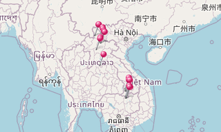
North Laos is divided into 8 provinces (Bokeo, Hua Phan, Luaung Nam Tha, Luang Prabang, Phongsali, Saiyabuli, Oudomxay, Xieng Khuang). Luang Prabang (also Louangphabang) is a province in northern Laos. Its capital of the same name, Luang Prabang, was the capital of Lane Xang Kingdom during the 13th to 16th centuries.
Phongsaly Province (also spelled Phôngsali), is a province of Laos in the extreme north of the country. Oudomxay (also Oudômxai or Moung Xai) is a province of Laos, located in the northwest of the country. The topography of Oudomxay is mountainous, between 300–1,800 m above sea level.
Ban Banakoi, Ban Hoy Bo and Ban Na are villages in the North Laos.
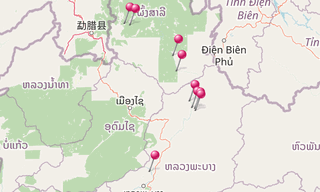
Muang Khua
Muang Khua is a village in Laos on the Nam Ou, near the Vietnamese border, in the province of Phongsali. The best way to get in the village from other parts of the country is by boat.
Muang Ngoi
Muang Ngoi Neua (Muang Ngoi or Muang Ngoi Gao) is a Lao village along the Nam Ou in Luang Prabang Province. It is part of Ngoi district 170 km North-East of Luang Prabang. The current population is about 700, and of Lao Loum ethnicity.
Nam Ou
The Nam Ou is a tributary of the Mekong flowing entirely in northern Laos. It originates in the province of Phongsaly, near the Chinese border, and flows south to the province of Luang Prabang. It flows into the Mekong north of Luang Prabang, at a place called Pak Ou, known for its cliffs and caves housing hundreds of Buddha statues.
Oudomxay
The province of Oudomxay is a province in the northwest of Laos. The inhabitants of this very mountainous region live mainly from agriculture (rice, corn…). Muang Xay, sometimes called Oudomxay, is the capital of Oudomxay province.
Pak Ou
Pak Ou is a village in Laos located in the province of Luang Prabang, in the district of Pak Ou, east of Luang Prabang. It is in this village that the caves of Pak Ou are located. The Tham Ting (lower cave) and the Tham Theung (upper cave) are caves overlooking the Mekong River, 25 km to the north of Luang Prabang.
They are a group of two caves on the west side of the Mekong River. The caves are noted for their miniature Buddha sculptures. Hundreds of very small and mostly damaged wooden Buddhist figures are laid out over the wall shelves. They take many different positions, including meditation, teaching, peace, rain, and reclining (nirvana).
Phongsali
Town at altitude of 1,626 m. The province of Phongsali is the northernmost province of Laos. It borders on Yunnan (China) and the province of Điện Biên (Vietnam). Crossed over its entire length by the Nam Ou, a tributary of the Mekong, it is the main trade route between Laos and China. The province is very mountainous and mainly covered with forests.
Tat Kuang Si Waterfalls
The Kuang Si Falls or Kuang Xi Falls, alternatively known as the Tat Kuang Si Waterfalls, is a three-tiered waterfall about 29 km south of Luang Prabang. The waterfalls begin in shallow pools atop a steep hillside. These lead to the main fall with a drop of 60 m. They are accessed via a trail to a left of the falls. The water flows into a turquoise blue pool before continuing downstream. The many cascades of Kuang Si are not typical of waterfalls, adding to the attractiveness.
.hero.jpg?w=320)