.hero.landscape.jpg?w=1600)

.jpg)
.jpg)
.jpg)
.jpg)
.jpg)
.jpg)
.jpg)
.jpg)
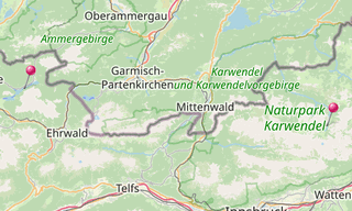
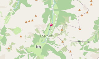
The Große Ahornboden lies at the head of the Rißtal valley, the Enger valley, just before the village of Eng between 1080 and 1300 m above sea level in the municipality of Vomp (district Schwaz). As early as 1927, the “Maple Trees near Alpe Eng on the Great Maple Soil” were declared a natural monument; it is one of the oldest environmental support of natural monuments in Tyrol. On December 20, 1988, the Great Maple Soil was designated as a conservation area, which covers 267.28 hectares. It is also part of the Alpenpark Karwendel.
The area is covered with numerous 300 to 600 year old and very gnarled maple trees. In 1966, 2,409 trees were counted. It is unclear why this extensive tree population could develop on the area used as grazing land for centuries. Cattle epidemics or the Thirty Years’ War may have meant that the valley floor was not grazed for a long time.
Mountain maples are around 500 years old, many of the trees in the Große Ahornboden have therefore reached their natural age limit. As natural regeneration does not work due to changes in soil and water conditions, as well as the grazing cattle and deer, dead trees are replaced by new plantings.
/Geroldsee-(269).hero.jpg?w=320)
.hero.jpg?w=320)