-Wat-Luang.hero.landscape.jpg)

.jpg)
.jpg)
.jpg)
-Tad-Hang-Waterfall.jpg)
.jpg)
-Wat-Luang.jpg)
-Alms-to-the-Monks.jpg)
.jpg)
-Fishing-on-the-Mekong.jpg)
-Fishing-on-the-Mekong.jpg)
.jpg)
.jpg)
.jpg)
-Market.jpg)
-Alms-to-the-Monks.jpg)
.jpg)
.jpg)
-Fishing-on-the-Mekong.jpg)
-Market.jpg)
.jpg)
.jpg)
.jpg)
-Fishing-on-the-Mekong.jpg)
.jpg)
-Fishing-on-the-Mekong.jpg)
.jpg)
.jpg)
.jpg)
-Mekong.jpg)
-Coffee.jpg)
.jpg)
-Alms-to-the-Monks.jpg)
-Alms-to-the-Monks.jpg)
-Mekong.jpg)
-Market.jpg)
.jpg)
.jpg)
.jpg)
-Fishing-on-the-Mekong.jpg)
.jpg)
-Fishing-on-the-Mekong.jpg)
.jpg)
-Mekong.jpg)
.jpg)
.jpg)
-Alms-to-the-Monks.jpg)
.jpg)
-Alms-to-the-Monks.jpg)
South Laos is divided into 4 provinces (Attapeu, Champasak, Salavan, Sekong). Champasak (Champassak or Champasack) is a province in southwestern Laos, near the borders with Thailand and Cambodia. It is one of the three principalities that succeeded the Lao kingdom of Lan Xang.
The capital is Pakse, but it takes its name from Champasak, the former capital of the Kingdom of Champasak. The Mekong River forms part of the border with neighboring Thailand and contains Si Phan Don (“Four Thousand Islands”) in the south of the province, on the border with Cambodia.
Champasak has some 20 wats (temples), such as Wat Phou, Wat Luang, and Wat Tham Fai.
Boloven Plateau
The Bolaven Plateau is a 1,200 m high and 10,000 km² large plateau in Laos. Most of the plateau is located in the Champasak province. Various ethnic groups that belong to the Mon Khmer language family live on the plateau. With around 50,000 people, the largest group is that of the lavas. The plateau was named after them (Bolaven - home of the lavas). In the region, agriculture is mainly practiced
Rubber, cardamom, pepper, green tea and coffee are grown, which gives the plateau national importance. The Tad Fane (the highest waterfall in Laos at 120 m) and the waterfalls Tad Phasuam, Tad Lo, Tad E-Tu, Tad Champee and Tad Nyuang are located in the Bolaven Plateau.
Don Khon Island
Don Khon is an island in the Si Phan Don archipelago on the Mekong River in Laos. The island is 5 km long and 3 km wide. The Don Det – Don Khon railway was a 7-km-long narrow-gauge portage railway on the islands of Don Khon and Don Det, opened in 1893 to transport vessels, freight, and passengers along the Mekong River, and closed since the 1940s.
Don Khong Island
Don Khong Island is a river island in the Mekong in the southern Laotian province of Champasak. The (depending on the water level) in north-south direction about 16-18 km long and up to 8 km wide island is located in the north of the area Si Phan Don (four thousand islands) and represents the main island of the region. It is the largest Laotian island and around one of the largest islands in the Mekong. The main town of the island is Muang Khong in the east, which is also the administrative seat of the Khong district.
Pakse
Pakse, also Pakxe, French Paksé or Pakxé, translated “mouth of the Se river”; is with 119,848 inhabitants (2010) the third largest city of Laos on the Mekong and capital of the Champasak province in the south of the country.
Khone Falls, Pha Pheng Falls and Li Phi Falls
The Khone Falls and Pha Pheng Falls together form a waterfall located in Champasak Province on the Mekong River in southern Laos, near the border with Cambodia. With 10,783 m wide, the Khone Falls are the largest in southeast Asia, and are the main reason that the Mekong is not fully navigable into China.
The falls are characterised by thousands of islands and countless waterways, giving the area its name Si Phan Don or “the 4,000 islands”. The highest falls reach to 21 m; the succession of rapids stretch 9.7 km of the river’s length. The average discharge of the cataract is nearly 11,000 m³/s, with the highest flow on record at over 49,000 m³/s.
Uo Moung
Uo Moung (Oum Moung) is a Khmer Hindu temple (Tomo) ruin in Champasak Province, in the south of Laos. It is believed to have been built late in the 9th century during the reign of the Khmer king Yasovarman I.
Vat Phu
Wat Phu (“mountain temple”) is a former Khmer temple complex in the Champasak province in southern Laos. The ruins that have been preserved, date from the 11th to 13th centuries. The “Wat Phou temple district and the associated ancient settlements in the Champasak cultural landscape” have been UNESCO World Heritage Site since 2001.
.hero.jpg?w=320)
.hero.jpg?w=320)
.hero.jpg?w=320)
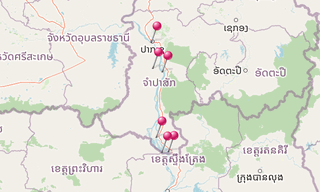
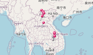
.map.png)
-Alms-to-the-Monks.jpg)
.jpg)
.jpg)
-Market.jpg)
.jpg)
-Market-Grilled-Frogs.jpg)
.jpg)
-Fishing-on-the-Mekong.jpg)
-Alms-to-the-Monks.jpg)
.jpg)
.jpg)
-Alms-to-the-Monks.jpg)
.jpg)
-Market.jpg)
.jpg)
.jpg)
-Coffee.jpg)
.jpg)
.jpg)
-Fishing-on-the-Mekong.jpg)
-Alms-to-the-Monks.jpg)
-Fishing-on-the-Mekong.jpg)
-Wat-Luang.jpg)
-Market.jpg)
.jpg)
.jpg)
-Coffee.jpg)
-Coffee.jpg)
.jpg)
-Market.jpg)
.jpg)
.jpg)
.jpg)
-Market.jpg)
.jpg)
-Alms-to-the-Monks.jpg)
-Chili-Pepper.jpg)
.jpg)
.jpg)
-Chili-Pepper.jpg)
-Grilled-Frogs.jpg)
-Tea.jpg)
-Alms-to-the-Monks.jpg)
-Fishing-on-the-Mekong.jpg)
-Market.jpg)
.jpg)
.jpg)
.jpg)
.jpg)
-Fishing-on-the-Mekong.jpg)
-Fishing-on-the-Mekong.jpg)
.jpg)
.jpg)
-Coffee.jpg)
.jpg)
-Market.jpg)
-Fishing-on-the-Mekong.jpg)
.jpg)
-Tad-Hang-Waterfall.jpg)
.jpg)
.jpg)
.jpg)
.jpg)
.jpg)
.jpg)
-Market.jpg)
.jpg)
.jpg)
.jpg)
.jpg)
.jpg)
-Fishing-on-the-Mekong.jpg)
-Grilled-Frogs.jpg)
.jpg)
-Fishing-on-the-Mekong.jpg)
.jpg)
.jpg)
-Chili-Pepper.jpg)
-Market.jpg)
.jpg)
-Market.jpg)
.jpg)
.jpg)
.jpg)
.jpg)
.jpg)
-Market.jpg)
-Fishing-on-the-Mekong.jpg)
-Fishing-on-the-Mekong.jpg)
-Market.jpg)
.jpg)
-Alms-to-the-Monks.jpg)
.jpg)
.jpg)
.jpg)
-Market.jpg)
.jpg)
.jpg)
.jpg)
.jpg)
.jpg)
.jpg)
-Fishing-on-the-Mekong.jpg)
-Fishing-on-the-Mekong.jpg)
.jpg)
.jpg)
.jpg)
.jpg)
.jpg)
.jpg)
-Fishing-on-the-Mekong.jpg)
-Market.jpg)
-Tea.jpg)
.jpg)
.jpg)
.jpg)
.jpg)
-Fishing-on-the-Mekong.jpg)
.jpg)
.jpg)
.jpg)
-Fishing-on-the-Mekong.jpg)
-Wat-Luang.jpg)
.jpg)
.jpg)
.jpg)
-Fishing-on-the-Mekong.jpg)
.jpg)
.jpg)
-Fishing-on-the-Mekong.jpg)
-Fishing-on-the-Mekong.jpg)
-Tad-Hang-Waterfall.jpg)
.jpg)
-Coffee.jpg)
.jpg)
.jpg)
.jpg)
.jpg)
.jpg)
.jpg)
.jpg)
-Market-Chili-Pepper.jpg)
-Coffee.jpg)
-Market.jpg)
-Tea.jpg)
.jpg)
.jpg)
-Alms-to-the-Monks.jpg)
-Grilled-Frogs.jpg)
.jpg)
.jpg)
-Tad-Fane-Waterfall.jpg)
.jpg)
.jpg)
.jpg)
.jpg)
.jpg)
-Market-Grilled-Frogs.jpg)
.jpg)
-Fishing-on-the-Mekong.jpg)
.jpg)
.jpg)
.jpg)
-Fishing-on-the-Mekong.jpg)
.jpg)
.jpg)
.jpg)
.jpg)
.jpg)
.jpg)
-Fishing-on-the-Mekong.jpg)
-Fishing-on-the-Mekong.jpg)
-Alms-to-the-Monks.jpg)
.jpg)
.jpg)
-Market-Grilled-Frogs.jpg)
.jpg)
-Market.jpg)
-Chili-Pepper.jpg)
.jpg)
.jpg)
.jpg)
Tad-Fane-Waterfall.jpg)
.jpg)
.jpg)
-Tad-Hang-Waterfall.jpg)
.jpg)
.jpg)
.jpg)
-Fishing-on-the-Mekong.jpg)
-Alms-to-the-Monks.jpg)
.jpg)