-Markiezenhof.hero.landscape.jpg)

-Markiezenhof.jpg)
-Markiezenhof.jpg)
-Markiezenhof.jpg)
-Markiezenhof.jpg)
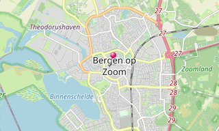
Bergen op Zoom is a city located in the south of the Netherlands. It was granted city status probably in 1212. In 1287 the city and its surroundings became a lordship as it was separated from the lordship of Breda. The lordship was elevated to a margraviate in 1559. Several families ruled Bergen op Zoom in succession until 1795, although the title was only nominal since at least the seventeenth century.
During the early modern period, Bergen op Zoom was a very strong fortress and one of the main armouries and arsenals of the United Provinces. It was at that time besieged by Alessandro Farnese first in 1587, and by Ambrosio Spinola a second time in 1622. Both sieges were unsuccessful and Bergen op Zoom got the nickname La Pucelle or The Virgin as it was never sieged successfully.
In 1747, during the War of the Austrian Succession, the French army laid siege to it again. At that time, Bergen op Zoom had fortifications built in the beginning of the 17th century by Menno van Coehoorn, with three forts surrounding the city and a canalised diversion of the Scheldt acting as a ditch around its walls.
However, it had no second line of fortifications, nor any fortress. After seventy days of siege, the city was taken and thoroughly sacked; the garrison was slaughtered.
.hero.jpg?w=320)
.hero.jpg?w=320)