.hero.jpg?w=1024)
Description
Agra Fort is a historical fort in the city of Agra in India. It was the main residence of the emperors of the Mughal Dynasty until 1638, when the capital was shifted from Agra to Delhi.
Before capture by the British, the last Indian rulers to have occupied it were the Marathas. In 1983, the Agra Fort was inscribed as a UNESCO World Heritage site.
It is about 2.5 km northwest of its more famous sister monument, the Taj Mahal. The fort can be more accurately described as a walled city.
It had been used by the early mughal rulers. The Fort stands on an ancient site and was traditionally known as Badalgarh, It was captured by Ghaznavi for some time but in the 15th century the Chauhan Rajputs occupied it. …
Show the remaining text
Soon after, Agra assumed the status of capital when Sikandar Lodi (1487–1517) shifted his capital from Delhi and constructed a few buildings in the pre-existing Fort at Agra.
After the first battle of Panipat (1526) Mughals captured the fort and ruled from it. In 1530, Humayun was crowned in it. The Fort got its present appearance during the reign of Akbar (1556–1605).
Map
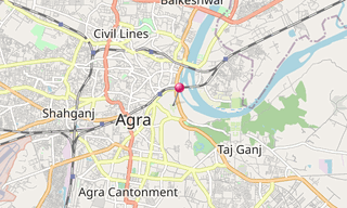
★ Open the Google Maps link in a new window at the location: Red Fort of Agra
Photo gallery
30 Photos
Photos 1 to 30
.jpg)
.jpg)
.jpg)
.jpg)
.jpg)
.jpg)
.jpg)
.jpg)
.jpg)
.jpg)
.jpg)
.jpg)
.jpg)
.jpg)
.jpg)
.jpg)
.jpg)
.jpg)
.jpg)
.jpg)
.jpg)
.jpg)
.jpg)
.jpg)
.jpg)
.jpg)
.jpg)
.jpg)
.jpg)
.jpg)
Related topics
.hero.jpg?w=320)
Agra
162 Photos
Agra, a city on the banks of the Yamuna River in the northern state of Uttar Pradesh, achieved fame as the capital of the Mughal Emperors from 1526 to 1658. …
.hero.jpg?w=320)
World Heritage Site (UNESCO)
7,850 Photos
Photo gallery of UNESCO World Heritage Sites. A World Heritage Site is a landmark or area with legal protection by an international convention administered …
.map.png)