-Ta-Izz.hero.landscape.jpg?w=1600)
-Ta-Izz.jpg)
-Ta-Izz.jpg)
-Ta-Izz.jpg)
-Ta-Izz.jpg)
-Ta-Izz.jpg)
-Ta-Izz.jpg)
-Ta-Izz.jpg)
-Ta-Izz.jpg)
-Ta-Izz.jpg)
-Ta-Izz.jpg)
-Ta-Izz.jpg)
-Ta-Izz.jpg)
-Ta-Izz.jpg)
-Ta-Izz.jpg)
-Ta-Izz.jpg)
-Ta-Izz.jpg)
-Ta-Izz.jpg)
-Ta-Izz.jpg)
-Ta-Izz.jpg)
-Ta-Izz.jpg)
-Ta-Izz.jpg)
-Ta-Izz.jpg)
-Ta-Izz.jpg)
-Ta-Izz.jpg)
-Ta-Izz.jpg)
-Ta-Izz.jpg)
-Ta-Izz.jpg)
-Ta-Izz.jpg)
-Ta-Izz.jpg)
-Ta-Izz.jpg)
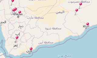
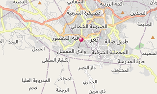
Taiz (Arabic: Ta’izz) is a city in the Yemeni Highlands, near the famous Mocha (Moka or Mokka) port on the Red Sea, lying at an elevation of about 1,400 m above sea level. It is the capital of Taiz Governorate. It is the third largest city in Yemen after the capital Sana’a and the southern port of Aden. When Yemen was at peace, it was considered to be the cultural capital of Yemen.
In 130 the Jewish quarter was established in the city. Taiz was ruled by Turan-Shah, the older brother of Saladin, after he had conquered Yemen in 1173. Turan-Shah built the citadel on the hill overlooking the old city. The second Rasulid King, Almaddhafar, established Taiz as the second capital of the Rasulid Dynasty after Zabid.
Taiz remained a walled city until 1948 when Imam Ahmed made it the second capital of Yemen, allowing for expansion beyond its fortified wall. The city has many old and beautiful quarters, with houses that are typically built with brown bricks, and mosques are usually white.
Most famous among the mosques are the Ashrafiya, the Muctabiya and the Mudhaffar.
-Sanaa.hero.jpg?w=320)