.hero.jpg?w=1024)
Description
Breiðamerkursandur (also called Diamond Beach for the pieces of glacial ice washed up on the beach) is a sandur (a glacial outwash plain) in southeast Iceland.
Sandur is the Icelandic word for sand and the whole area is mostly sand, although some vegetation is beginning to grow in the area.
The name of the sandur, Breiðamerkursandur, however means broad forest sand, which suggests that the area may have been heavily vegetated in the early centuries of the Icelandic settlement.
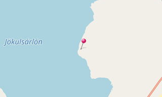
Breiðamerkursandur was formed by the glaciers Breiðamerkurjökull, Fjallsjökull and Hrútárjökull during the last few centuries. The lagoon Jökulsárlón is located on Breiðamerkursandur. …
Show the remaining text
The glaciers that formed the sandur are a part of Vatnajökull, and therefore a part of Vatnajökull National Park. However, neither the plain itself nor the Jökulsárlón lake are a part of the park.
Breiðamerkursandur is an important breeding ground for birds, for example Arctic tern and great skua.
Map
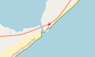
★ Open the Google Maps link in a new window at the location: Breiðamerkursandur
Photo gallery
17 Photos
Photos 1 to 17
.jpg)
.jpg)
.jpg)
.jpg)
.jpg)
.jpg)
.jpg)
.jpg)
.jpg)
.jpg)
.jpg)
.jpg)
.jpg)
.jpg)
.jpg)
.jpg)
.jpg)
★ Don’t miss: The most beautiful photos of Iceland
Related topics
-(295).hero.jpg?w=320)
Beaches
330 Photos
The most beautiful beaches around the world.
.hero.jpg?w=320)
Iceland
191 Photos
Iceland is a Nordic island country of Europe located in the North Atlantic Ocean. It has a population of 332,529 and an area of 103,000 km², making it the …
.hero.jpg?w=320)
Jökulsárlón
26 Photos
Jökulsárlón, literally “glacial river lagoon”, is a large glacial lake in southeast Iceland, on the edge of Vatnajökull National Park. Situated at the head …
-(121).hero.jpg?w=320)
Norway
131 Photos
Lofoten is an archipelago in the county of Nordland, Norway. Lofoten is known for a distinctive scenery with dramatic mountains and peaks, open sea and …