.hero.landscape.jpg)

.jpg)
.jpg)
.jpg)
.jpg)
.jpg)
.jpg)
.jpg)
.jpg)
.jpg)
.jpg)
.jpg)
.jpg)
.jpg)
.jpg)
.jpg)
.jpg)
.jpg)
.jpg)
.jpg)
.jpg)
.jpg)
.jpg)
.jpg)
.jpg)
.jpg)
.jpg)
.jpg)
.jpg)
.jpg)
.jpg)
.jpg)
.jpg)
.jpg)
.jpg)
.jpg)
.jpg)
.jpg)
.jpg)
.jpg)
.jpg)
.jpg)
.jpg)
.jpg)
.jpg)
.jpg)
.jpg)
.jpg)
.jpg)
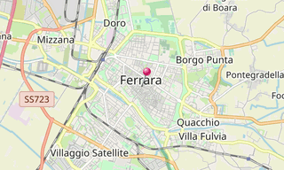
Ferrara is situated 50 km north-north-east of Bologna, on the Po di Volano, a branch channel of the main stream of the Po River, located 5 km north. The town has palaces dating from the 14th century and 15th century, when it hosted the court of the House of Este.
For its beauty and cultural importance it has been qualified by UNESCO World Heritage Site. The town is still surrounded by more than 9 km of ancient walls, mainly built in the 15th and 16th centuries. Together with those of Lucca, they are the best preserved Renaissance walls in Italy.
The most iconic building of the town is the imposent Castello Estense: sited in the very centre of the town. It was built starting in 1385 and partly restored in 1554; the pavilions on the top of the towers date from the latter year. Close by it is the former Cathedral of Saint George, begun in 1135 by Guglielmo I of Adelardi.
The campanile, in the Renaissance style, dates from 1451 - 1493, but the last storey was added at the end of the 16th century.
.hero.jpg?w=320)
.hero.jpg?w=320)
.hero.jpg?w=320)
.map.png)
.jpg)
.jpg)
.jpg)
.jpg)
.jpg)
.jpg)
.jpg)
.jpg)
.jpg)
.jpg)
.jpg)
.jpg)
.jpg)
.jpg)
.jpg)
.jpg)
.jpg)
.jpg)
.jpg)
.jpg)
.jpg)
.jpg)
.jpg)
.jpg)
.jpg)
.jpg)
.jpg)
.jpg)
.jpg)
.jpg)
.jpg)
.jpg)
.jpg)
.jpg)
.jpg)
.jpg)
.jpg)
.jpg)
.jpg)
.jpg)
.jpg)
.jpg)
.jpg)
.jpg)
.jpg)
.jpg)
.jpg)
.jpg)
.jpg)
.jpg)
.jpg)
.jpg)