-(034).hero.landscape.jpg)

-(034).jpg)
-(079).jpg)
-(055).jpg)
-(073).jpg)
-(163).jpg)
-(118).jpg)
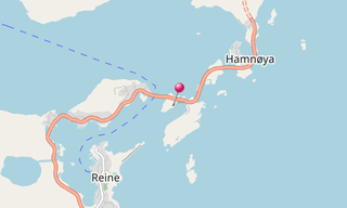
Sakrisøy (Sakrisøya) is a small island and a fishing village between Reine and Hamnøy in the municipality of Moskenes in Lofoten. The island is located in the Reinefjord, between Andøya and Olenilsøya. The highest point on the island is 18.5 m above sea level. European road E10 crosses Sakrisøy on the north side.
.hero.jpg?w=320)
-(121).hero.jpg?w=320)

.hero.jpg?w=320)
-(525).hero.jpg?w=320)