.hero.landscape.jpg)

.jpg)
.jpg)
.jpg)
.jpg)
.jpg)
.jpg)
.jpg)
.jpg)
.jpg)
.jpg)
.jpg)
.jpg)
.jpg)
.jpg)
.jpg)
.jpg)
.jpg)
.jpg)
.jpg)
.jpg)
.jpg)
.jpg)
.jpg)
.jpg)
.jpg)
.jpg)
.jpg)
.jpg)
.jpg)
.jpg)
.jpg)
.jpg)
.jpg)
.jpg)
.jpg)
.jpg)
.jpg)
.jpg)
.jpg)
.jpg)
.jpg)
.jpg)
.jpg)
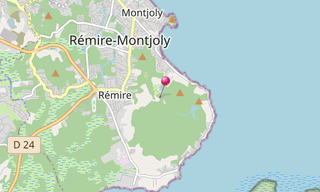
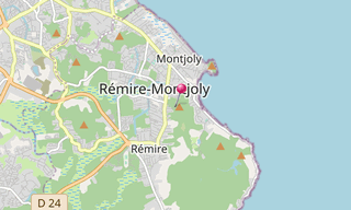
With a length of 5 km, the Rorota Trail (Sentier du Rorota) connects the lakes of Rorota, of Lalouette and of Rémire in the municipality of Rémire-Montjoly and is located on the northern edge of the Plateau of Mahury. This massive rises to 170 m and extends from the mouth of the Mahury to the Bay of Montravel.
The Mahury tray is an important water reservoir since the construction of the lakes that feed the drinking water treatment plant. Originally, it was the engineer of the Ponts et Chaussées, Lalouette, who had the idea of creating these lakes in order to constitute a reserve of drinking water to supply the population of Cayenne in the dry season.
For a long time this was the main source of supply of the city. The trail was initially only a way to monitor and maintain the water abstraction facilities.
.hero.jpg?w=320)
.hero.jpg?w=320)
.hero.jpg?w=320)
.hero.jpg?w=320)
.hero.jpg?w=320)
.hero.jpg?w=320)