.hero.landscape.jpg)

.jpg)
.jpg)
.jpg)
.jpg)
.jpg)
.jpg)
.jpg)
.jpg)
.jpg)
.jpg)
.jpg)
.jpg)
.jpg)
.jpg)
.jpg)
.jpg)
.jpg)
.jpg)
.jpg)
.jpg)
.jpg)
.jpg)
.jpg)
.jpg)
.jpg)
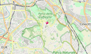
The Appian Way was one of the earliest and strategically most important Roman roads of the ancient republic. It connected Rome to Brindisi, Puglia, in south-east Italy. The road is named after Appius Claudius Caecus, the Roman censor who began and completed the first section as a military road to the south in 312 BC during the Samnite Wars.
Main sights
Porta Appia (Porta San Sebastiano), the gate of the Aurelian Walls, Church of Domine Quo Vadis, Catacomb of Callixtus, San Sebastiano fuori le mura, Catacombs of St Sebastian, Circus of Maxentius, Tomb of Cecilia Metella, Roman baths of Capo di Bove, Mausoleum of the Orazi and Curiazi, Villa dei Quintili, with nympheum, theatre, and baths, Mausoleum of Casal Rotondo, Minucia tomb, Torre Selce, Temple of Hercules, Berrettia di Prete (tomb and later church), Mausoleum of Gallienus
.hero.jpg?w=320)
.hero.jpg?w=320)
.hero.jpg?w=320)
.hero.jpg?w=320)